
Severe Weather Across the Country.
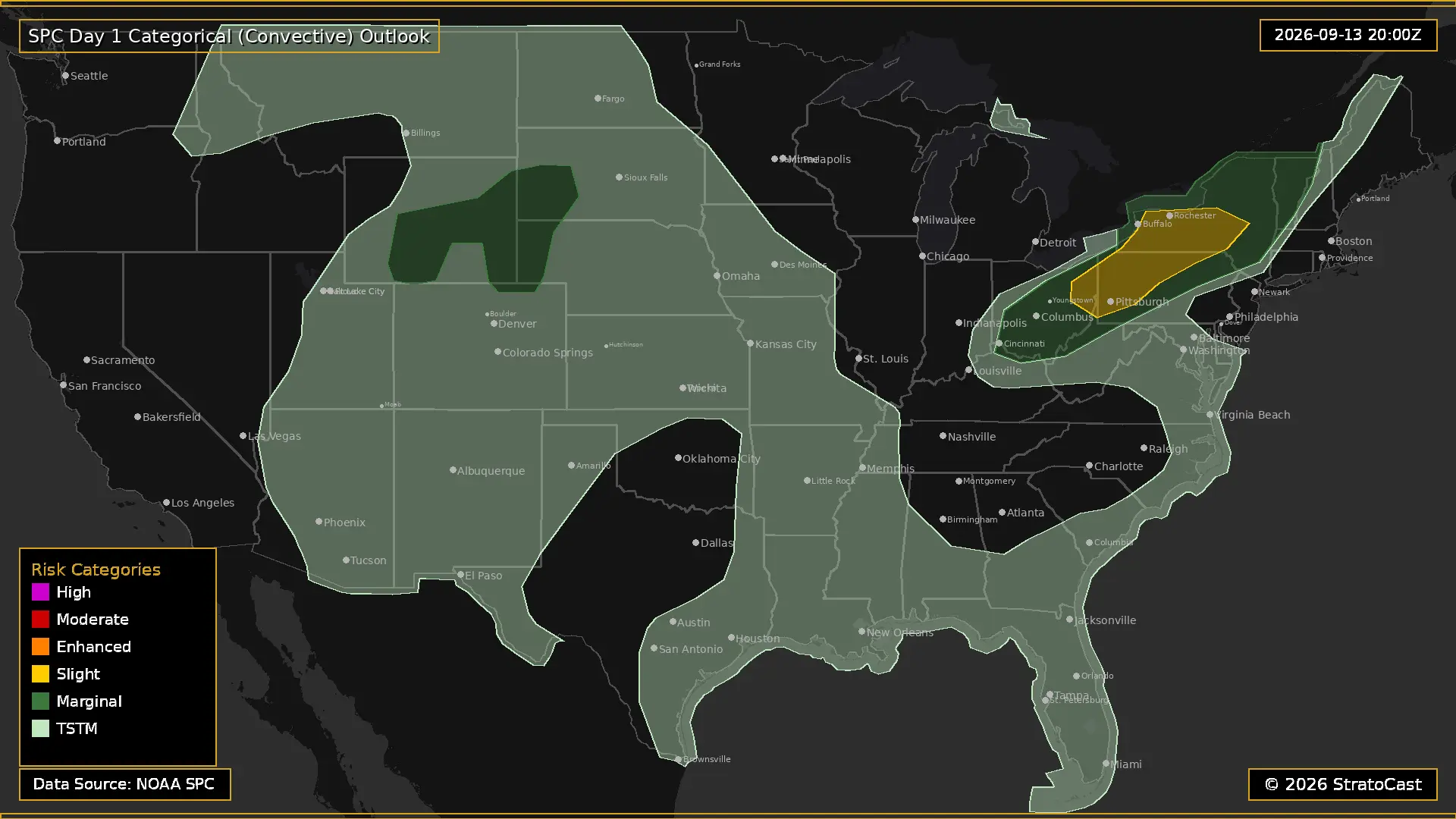
SPC Day 1 Outlook Showing The Slight Risk of Severe Weather for the Northeast
The first severe-weather threat of the week is taking shape across the Northeast and Upper Ohio Valley this afternoon and evening. The Storm Prediction Center has placed parts of the region under a Slight Risk for severe thunderstorms, with the greatest concern extending from Ohio and western New York eastward into parts of the Northeast.
A strong upper-level trough over Canada will help drive strong winds in the mid to upper levels of the atmosphere across the Great Lakes, Ohio Valley, and Northeast. At the same time, a cold front is pushing eastward through the region. A fairly moist airmass ahead of the front will provide fuel for thunderstorms, although widespread cloud cover and relatively weak temperatures aloft will limit how unstable the atmosphere can become.
Even with those limitations, the increasing wind shear will give thunderstorms enough organization to become locally severe. Storms are expected to develop during the mid to late afternoon, roughly between 3 and 6 PM, from parts of Ohio into western New York before spreading eastward through the evening.
Initially, a few storms could become supercells, bringing an isolated threat for large hail. However, the more prominent threat will quickly become straight-line damaging winds as storms merge into clusters and bowing line segments along the cold front.
The severe threat should gradually diminish this evening as temperatures fall and storms encounter a less unstable environment farther east.
Elsewhere, there will be a more isolated severe-weather threat across the central and northern High Plains. A low-pressure system moving out of the Pacific Northwest will reach the northern Rockies and High Plains, where modest instability and favorable wind profiles could allow a few thunderstorms to become strong or severe across southern Wyoming, northeastern Colorado, and the Nebraska Panhandle. Large hail and damaging winds will be the primary concerns.
Later tonight into early Monday morning, thunderstorms are also expected to increase across western and central South Dakota and into the Missouri Valley. A few of these storms could produce hail, although weakening instability and interactions between storms should keep the overall severe threat relatively limited.
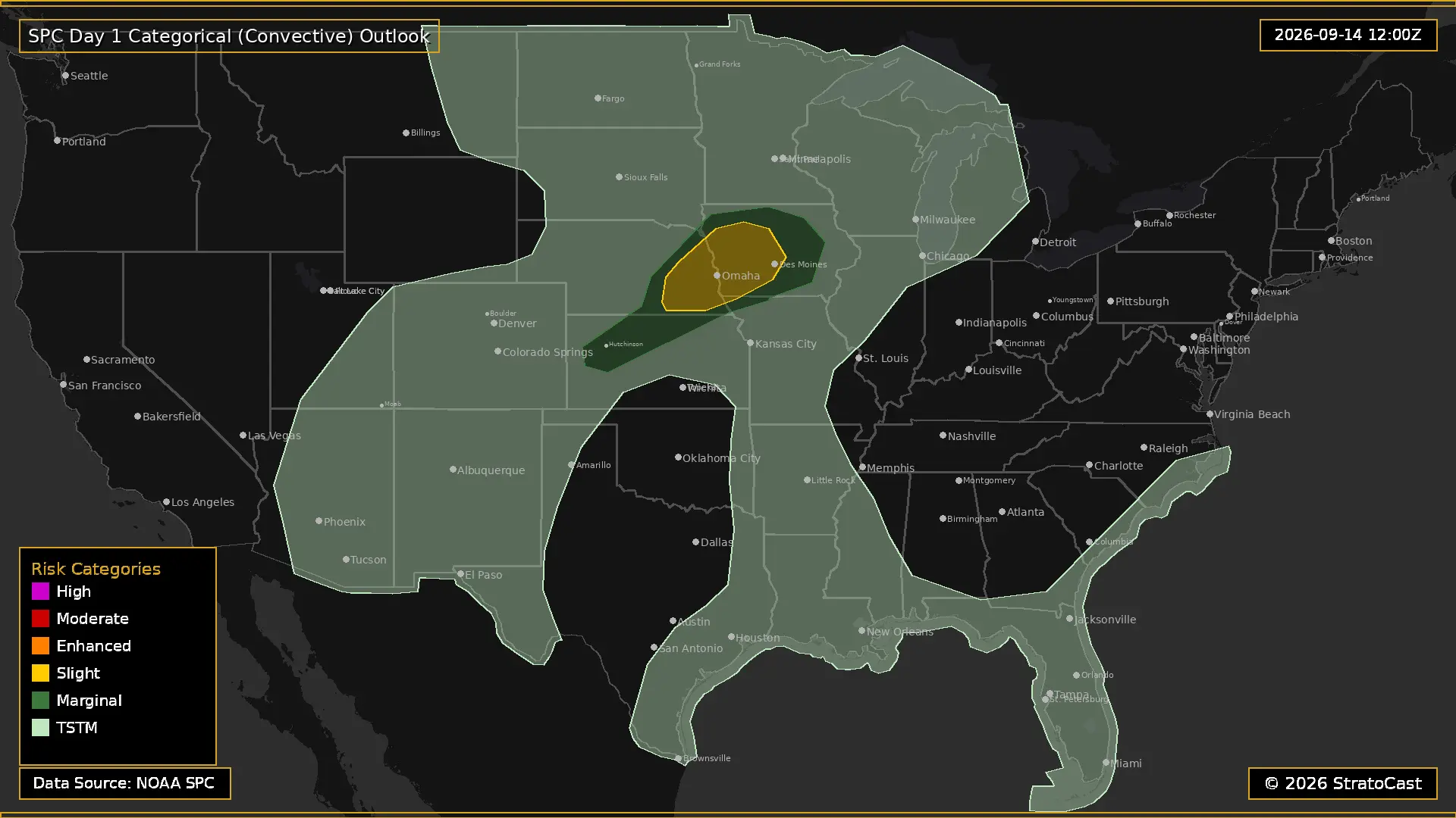
SPC Day 2 Outlook Showing The Slight Risk of Severe Weather for Nebraska and Iowa
On Monday the severe weather threat will shift towards the west with the main focus being southeast Nebraska and western Iowa. The Storm Prediction Center has placed this area under a Slight Risk for severe thunderstorms, with scattered strong to severe storms possible during the late afternoon and early evening.
A mid-level trough will move across the northern Plains on Monday, accompanied by a strengthening jet streak with winds of 60 to 70 knots. At the surface, low pressure will develop across the central Plains while a larger low remains farther north over the Canadian Prairies. Meanwhile, moisture will continue to surge northward, bringing dewpoints in the mid to upper 60s into Nebraska and Iowa.
Some thunderstorms will likely already be ongoing Monday morning across eastern South Dakota, Minnesota, and Iowa. Behind this morning activity, however, the atmosphere is expected to recover across northeast Kansas, southeast Nebraska, and southwest Iowa. This recovery will be important because a narrow window of favorable conditions could develop during the afternoon ahead of the advancing front.
If this occurs as forecast, storms could develop in an environment with more than 2,500 J/kg of MLCAPE (moderate instability) and 30 to 35 knots of effective wind shear. Those conditions would be supportive of supercells, particularly across southeast Nebraska into western Iowa.
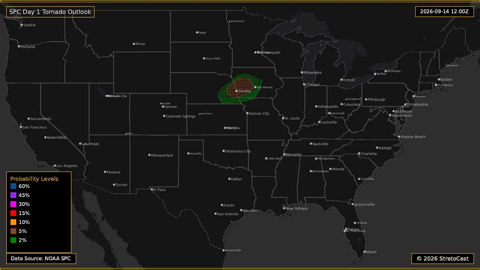
SPC Day 2 Outlook Showing The Tornado Risk of Severe Weather for Nebraska and Iowa
Model soundings indicate a highly favorable low-level environment for tornadoes. The streamwise vorticity in the lowest 2 kilometers of the atmosphere is expected to be favorable for EF2+ tornadoes. However, there are some limiting factors. The first is uncertainty as to how long storms will remain discrete. Should storms merge together and form a line or cluster, that would severely hinder the tornado threat, which would be good news for those in the risk area. Another limiting factor is that the wind shear in the upper levels will not be ventilating the storms efficiently. This means that these storms could become outflow-dominant before an organized low-level circulation has time to develop. However, should a storm overcome these obstacles, it would likely have a much greater chance of producing a tornado.
Shifting towards the southwest, strong afternoon heating and moderate instability could support a few additional thunderstorms capable of producing damaging wind gusts and isolated large hail. The overall threat should be more scattered in this area, but some storms could still become locally severe.
Thunderstorms will also continue through the night across parts of southern Wisconsin and northern Illinois as a strong low-level jet transports moisture northward. However limited instability and weaker shear should keep the threat relatively low.
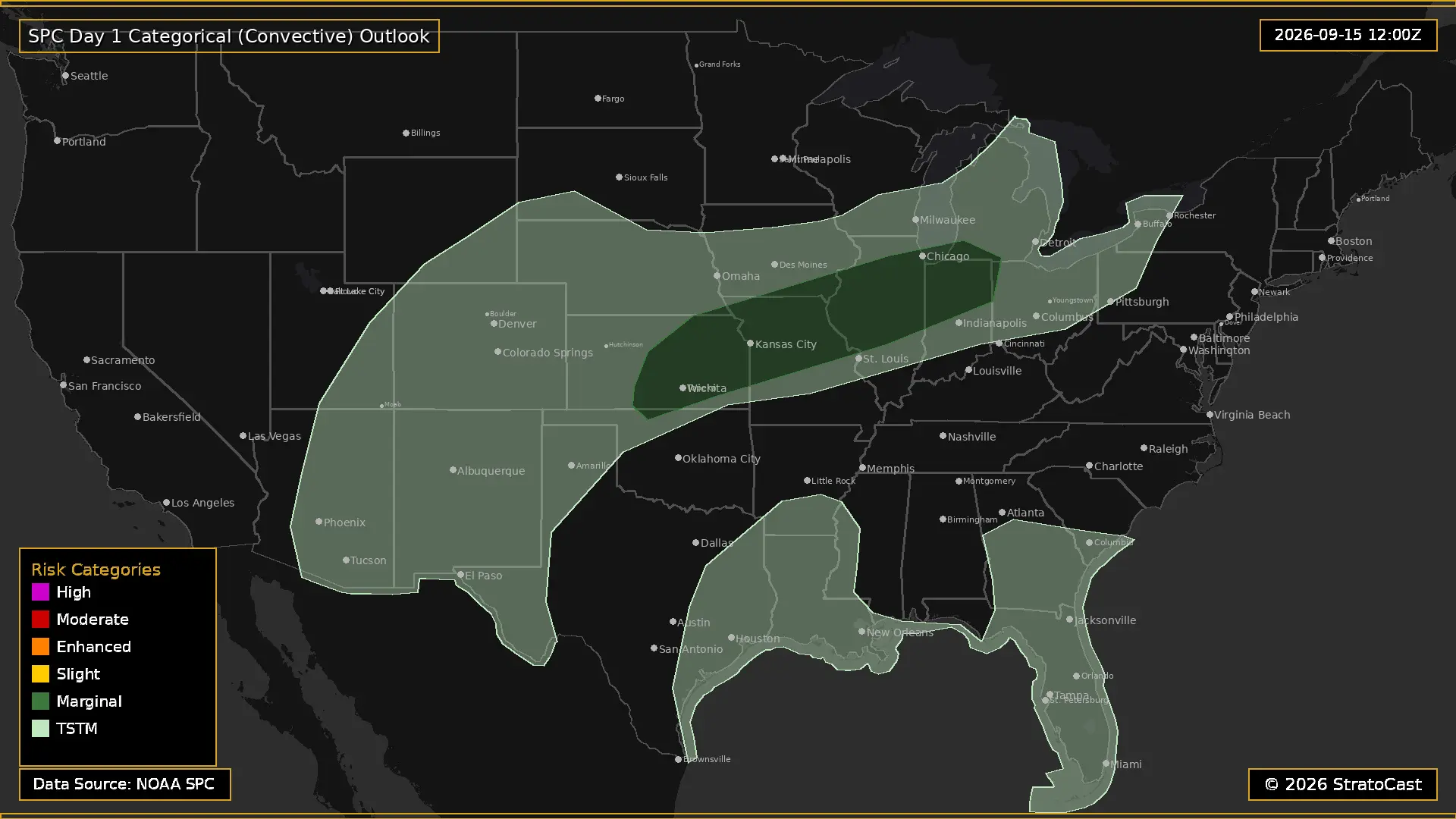
SPC Day 3 Outlook Showing The Marginal Risk of Severe Weather for Central Plains Into the Midwest
By Tuesday the severe weather threat begins to wane. A mid-level trough will move into Ontario as a ridge builds across the Midwest. At the surface, a cold front will slowly move southeastward from southern Iowa and northern Kansas early Tuesday, eventually reaching northern Oklahoma and central Missouri by early Wednesday morning. Dewpoints in the low to mid 70s south of the front will provide plenty of moisture, with weak to moderate instability expected to develop.
Forcing will be somewhat weak, however the moderate to strong instability should yield some thunderstoms capable of severe windgusts. Some lingering 30-40 knot mid-level wind flow could linger across portions of the midwest which could aid in organizing these storms, however supercells are unlikely.
When we look out even further, we see that the severe weather threat really wanes, with only minor severe weather threats expected during the 4 to 8 day range. The lack of severe weather does not necessarily mean that we will have quiet weather. In fact, for many, the main event will not be the severe weather, but rather the flooding.
Flood Threat.
The Weather Prediction Center has issued a Slight Risk for excessive rainfall is in place across portions of the Northeast and Central Plains today. Across the Central Plains, a slow-moving frontal boundary combined with a strengthening low-level jet will continue to transport large amounts of moisture into the region. Eastern Kansas and western Missouri appear to be favored for heavier rainfall, including the Kansas City area. While storms should remain progressive enough to limit the overall flash flood threat for now, additional thunderstorms developing tonight could produce locally heavy rainfall and begin setting the stage for a more significant flooding threat farther north into the Midwest.
Farther north, a strong closed low developing over the northern Rockies will help pull an unusually moist air mass into the Northern Plains and Midwest. Precipitable water values are expected to reach well above normal for this time of year, and repeated rounds of showers and thunderstorms could produce locally heavy rainfall. The exact placement of the heaviest rain remains uncertain, but portions of the Central Plains into the Midwest will need to be watched closely as additional storms develop.
Farther west, the Marginal Risk across the Southwestern United States has been expanded as thunderstorms have developed in an environment with high instability outside the previously outlined risk area. Additional monsoonal moisture will continue moving into the Southwest and Southern Rockies, while soils remain increasingly saturated from recent rainfall. This combination will make the region more susceptible to flash flooding, particularly where thunderstorms repeatedly move over the same areas. The Southwest will therefore remain another area to watch for locally heavy rainfall and flooding through tonight.
As we look towards tomorrow, Monday, the flooding threat inceases, particularly across the Midwest. A strong upper-level low over the northern Rockies will work with a strong ridge over the Mid-South to funnel an exceptional amount of moisture northward into the region. Precipitable water values are expected to reach above the 99th percentile for this time of year, meaning the atmosphere will have an unusually large amount of moisture to work with. Widespread showers and thunderstorms are expected, with efficient rainfall processes allowing some storms to produce heavy rain.
The greatest concern will be along and near the warm front, where organized clusters of thunderstorms could develop. Current forecasts call for widespread rainfall totals of 1 to 2 inches from eastern Nebraska into the Upper Great Lakes, with locally higher totals exceeding 3 inches possible. The exact location of the heaviest rainfall remains uncertain, but the overall setup supports a continued Slight Risk for excessive rainfall across much of the region. With additional storms expected later in the week, some areas will likely begin accumulating several rounds of heavy rainfall.
The Southwest will also remain active on Monday as monsoonal moisture continues flowing into Arizona, New Mexico, and the surrounding areas. Precipitable water values will remain well above normal, while recent rainfall has already left soils increasingly saturated. The Slight Risk has been expanded across southeastern Arizona and western New Mexico, with a broader Marginal Risk extending across much of the Southwest and into the Colorado Rockies. Additional thunderstorms could therefore produce localized flash flooding, particularly in areas that have received heavy rain in recent days.
On Tuesday the flooding threat remains across the Central Plains and Midwest. Models continue to show exceptionally moist air spreading from the central High Plains toward the Missouri River Valley, with precipitable water values once again expected to exceed the 99th percentile for this time of year. A stationary front stretching from Kansas into central Illinois will provide a focus for repeated rounds of thunderstorms, while a strengthening low-level jet will transport even more moisture into the region Tuesday night
The setup is especially concerning across northeast Kansas and northern Missouri, where storms could repeatedly develop and train over the same areas. A strong jet streak over the Great Lakes will provide additional lift across the Central Plains, while persistent southwesterly flow will continue feeding moisture into the frontal boundary. This could allow training and back-building thunderstorms to develop, producing rainfall totals of 2 to 3 inches with locally higher amounts exceeding 4 inches. The exact location of the heaviest rainfall remains uncertain, which is preventing a higher risk category, but the latest forecast characterizes this as a high-end Slight Risk area. As details get more defined it is possible that we get an upgrade to a level 3/4 Moderate risk.
The Southwest will also remain under a Slight Risk for excessive rainfall, particularly across eastern Arizona and western New Mexico. Monsoonal moisture will remain well above normal, and recent rainfall will leave soils increasingly saturated. Additional forcing from the upper-level pattern should support another round of scattered showers and thunderstorms. While instability may be somewhat limited after an active Monday, the combination of very moist air, saturated soils, and favorable large-scale forcing will continue to support localized flash flooding.
And unfortunately Wednesday is a similar story. The heavy rainfall threat will continue across the Central Plains, Missouri Valley, Corn Belt, and Upper Midwest. A slow-moving front will remain in place across the region, allowing additional rounds of thunderstorms to develop. This additional rain over already saturated ground will likely lead to more flooding problems.
The Southwest will also remain active, particularly across eastern Arizona and New Mexico. Another round of widespread thunderstorms is expected as monsoonal moisture remains well above normal. Rainfall totals of 1 to 2 inches will be possible across broad areas, with locally higher amounts. Saturated soils, urban areas, and burn scars will likely be the most vulnerable.
By Thursday, the pattern will begin to shift somewhat. High pressure moving across the Northern Plains should push the front farther south and temporarily bring some drier air into portions of the Central Plains and Upper Mississippi Valley. However, another round of organized thunderstorms is expected Thursday night as the low-level jet strengthens and energy moves out of the Southwest. The favored area currently stretches from northeast Colorado into Nebraska and southern South Dakota, potentially reaching western Iowa. The exact location remains uncertain this far out, but the potential for training storms and heavy rainfall is enough to maintain a Slight Risk. Meanwhile, another day of thunderstorms is expected across the Southwest, particularly New Mexico.
The Tropics.
We are now officially breaking records for the latest date on which a hurricane has formed in the Atlantic basin. The previous record was September 11, set in both 2002 and 2013. We are already at September 13, and the Atlantic still has not produced a hurricane this season. While that streak will continue for at least the next several days, there is a chance that we get another tropical system.
A disturbance is currently being monitored over the central subtropical Atlantic, where disorganized showers and thunderstorms are associated with a trough of low pressure. Strong upper-level winds are making conditions unfavorable for development right now, but the system is expected to move into a somewhat more favorable environment by the middle to latter part of this week. The disturbance is forecast to move west-northwestward across the central Atlantic.
For now, the odds of development remain low. The National Hurricane Center gives the system near a 0 percent chance of developing over the next 48 hours and a 20 percent chance of development over the next seven days. So while there is a chance that it could develop into a tropical storm, it does not look particularly likely at the moment.
The Heat.
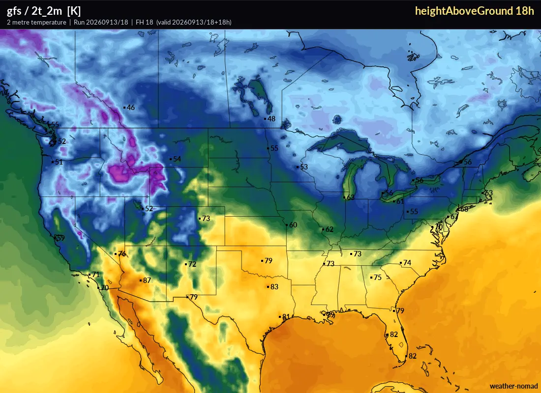
2 P.M. EDT GFS Model Run 18 Hours Out. (7 A.M. CDT. September 14, 2026) Showcasing Cooler Air in the Upper Midwest
Portions of the Upper Midwest could actually see frost tonight into tomorrow morning. The National Weather Service has issued Frost Advisories for northern Minnesota and northern Wisconsin, where temperatures are expected to fall into the low to mid 30s. That will be cold enough for frost to develop in some areas.
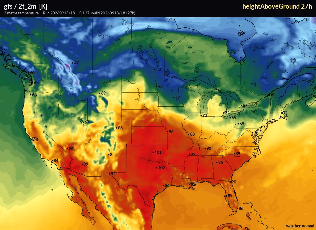
2. P.M. EDT GFS Model Run 27 Hours Out. (4 P.M. CDT. September 14, 2026) Showcasing the Heat Dome Across the Southern U.S.
Meanwhile, the heat dome is once again picking up steam as it shifts eastward. Heat Advisories are in effect across portions of the South-Central U.S. and Ohio Valley, where heat indices are expected to remain above 100°F. Texas and Oklahoma are likely to bear the brunt of the heat, with heat indices potentially reaching 107 to 111°F. If you are outside during this heat, make sure to take frequent breaks to allow your body to cool down and stay well hydrated.
Looking a few days into the future, this relentless heat dome is expected to retrograde west-southwest and become suppressed toward lower latitudes. This should allow additional cold fronts to push farther into the Southeast and bring cooler air to portions of the region. Unfortunately, I still do not see a meaningful cooldown coming for the South-Central U.S. just yet. However, as the ridge becomes further suppressed later this week into the weekend, temperatures could ease back somewhat. We may still be dealing with temperatures in the 90s, but hopefully we can finally put the triple-digit temperatures behind us for a while.
And with that, we have reached the end of another forecast. Thank you for taking the time to read it.
If you found this forecast helpful, please consider sharing it with others who may find it useful as well. And as always, feel free to leave a comment if you have any feedback, questions, or suggestions. Your feedback helps me continue improving these forecasts.
There is certainly a lot to watch over the coming days, and I'll continue monitoring the situation and providing updates as needed.With that said, stay safe, keep an eye on the forecast, and have a great day, everyone. I'll see you next time!